I Once Was in Maps, but Now I’m Found
I was very excited about Apple Maps when the rumors surrounding its launch circulated in 2012. The Google contract for map data was going to expire but the company that deeply respects its customers would have something amazing. I cautiously updated my iPad (3) to iOS 6 to test it out, and didn’t update my iPhone 4 to iOS 6 until the following January, when the Google Maps app was available. There’s no denying how bad it was, because Tim Cook even wrote a statement apologizing for it.
I keep testing out Apple Maps every few months to see what’s happening with it – Usually when major updates are announced, or when some tech-pod-blog-ocaster mentions a positive experience. I would like to be pleasantly surprised, and then remove Google Maps. They are a company that specializes in personalized ad tracking, and here I am, shoving my location in their face.
Instead, here we are, three years later. Still working around Siri, and working around apps that integrate Apple Maps (like Yelp), and copying and pasting addresses in to Google Maps.
Works for Me
When I have discussed my issues with Apple Maps in the past I’ve received feedback that was not entirely helpful. Informing me about how well Apple Maps works in places I am not has done very little to improve how Apple Maps works here.
Telling me that I can report issues from inside the Maps app is something I already know, and have talked about in the past. It is safe to assume I have reported the complaints detailed below. Expressing my disappointment is not mutually exclusive to reporting issues. They’ve spent three years working on Maps, and made a big song and dance number about it at WWDC in June. I am not being overly critical of some just-launched beta from a startup.
However, I must apologize for ignoring the earnest advice to move somewhere else. I’m sure if I moved somewhere my job wasn’t then the quality of a maps and directions app would be unimpeachable.
Location, Location, Location?
There have been several improvements to location data both in the map view itself, and from the various iOS features which hook in to apps. Certainly this is much better than when the service launched with multiple, conflicting addresses for locations, and conflicting Yelp reviews. Even last year, when I bought my iPhone 6 with iOS 8, the location data was still pretty wonky. One particular test I conducted was asking for directions to “City Hall”.
The Maps app now correctly lists the city hall for the city I’m in right now (Los Angeles) as the first suggestion when I type the query, and follows it up with the other halls that are closer to me, but not the city hall of the city I’m in. For some inexplicable reason, “City Hall” in Philadelphia, Pennsylvania is still listed as a suggestion. At least it is no longer the primary result.
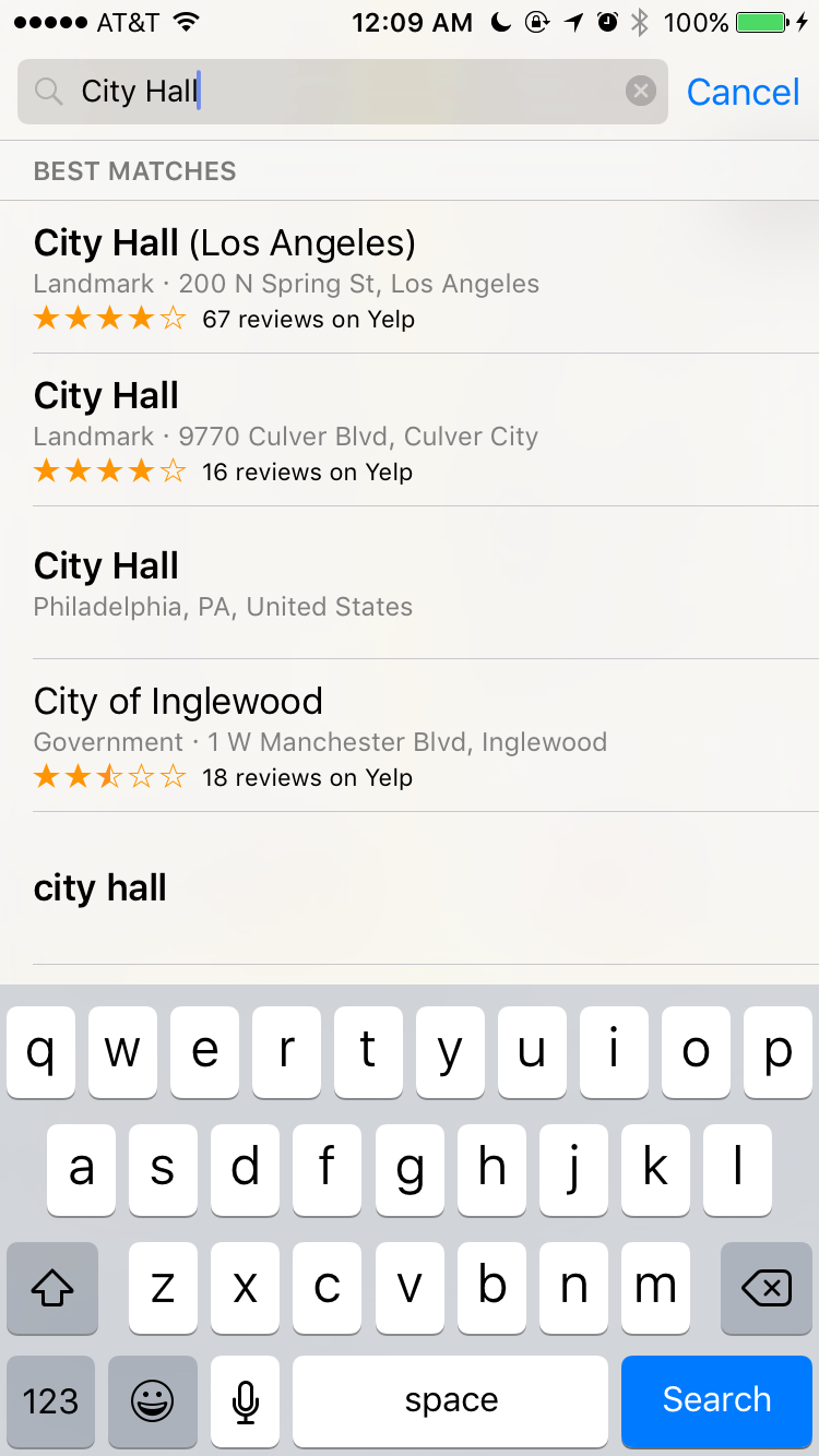
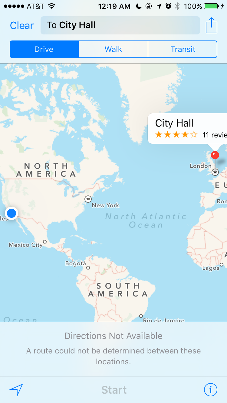
However, if I hit “search” without selecting one of the suggestions, I receive “City Hall, London”. Not to spoil any surprises, but if you click the little car icon for driving directions the app will regretfully inform you that it could not determine a route.
Confusingly, when I ask Siri for directions to city hall, I am presented with a list of locations that’s completely different from those suggestions the Maps app generates, and one of them is a gospel hall.
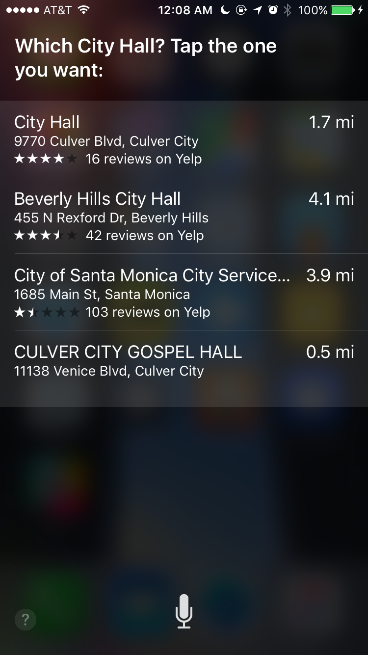
I don’t understand why these results are all different. Even if it’s struggling with the generic term, it should have the same struggle everywhere.
What about “Downtown LA”?
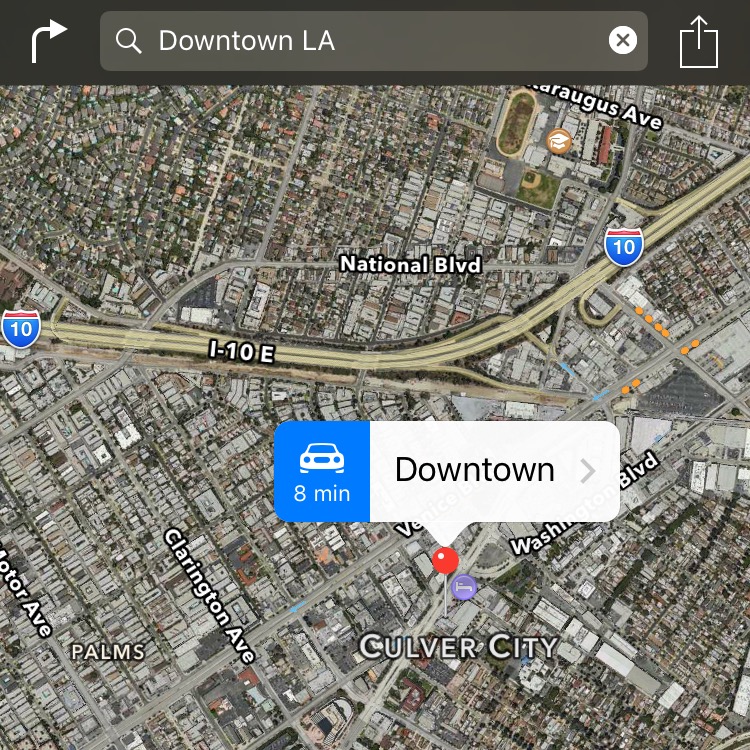
No, Apple Maps. I can’t even.
On a more positive note: Someone at Apple accepted one of the many reports I’ve been sending about my apartment address. I check every six to eight months, so I’m not exactly sure when they fixed my address. I no longer need to get route guidance to my neighbors’ buildings, and I can use Siri commands like, “Give me directions home”. This is a very exciting development for me.
The other location improvements have less significance to me, but I do still miss Google’s Street View. If you tap on an address that has no Yelp data you get a spartan, white page with a slowly rotating satellite view of the street, which is useless.
Categories for nearby locations are very nice, and I haven’t come across anything miscategorized, but I have a nit to pick about it all being radial to your location, and you can’t build a route. This is tricky, I know, but gas stations along my commute are more helpful than a radial cluster of pins from wherever I am along that commute. Waze has these sorts of features, but I had poor performance from their app and removed it in frustration. It would be nice if Siri could leverage the categories, and the route I’m on, as if it was some kind of virtual assistant.
LA Transit
(Update: I took Apple’s announcement at WWDC that iOS 9 would have transit support in LA to mean it would be included when iOS 9 launched. According to a page buried on Apple’s site, they have not rolled out Los Angeles support yet.)
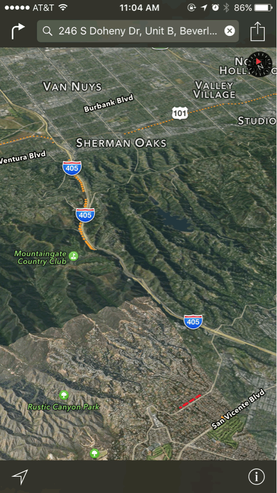
Transit directions are of academic interest to me, but I have no real ability to test them other than trying a few random queries. While Apple has made arrangements for public transit data in LA, it seems to be very incomplete. No bus routes are available when I conducted some searches on the Westside. I also conducted a search from Culver City to the Los Angeles Convention Center, which should have shown me the Expo Line light rail route, but instead I got the same error as the buses. “Transit directions are not available between these locations. View routing apps.” I can select the installed Google Maps app and I’m presented with the Expo Line. It doesn’t even flinch. Maybe there are some routes that function in LA, since Apple listed LA as a city they would have this data for, but I can’t think of any.
Perceived Slowness
Since the Apple Maps app was introduced, the slow, whimsical animations have bugged the crap out of me. You don’t always see them, sometimes it just snaps directly to the relevant view. Other times it involves a lot of slow pans and zooms. I don’t need to see all of North America while the app slowly zooms in to where I am. I am pretty aware of where North America is in relation to me.
3D also seems to add some processing weight to the situation, which I don’t really need. Building height is one of those metrics they got from their aerial mapping that’s neat in demos, but doesn’t serve any purpose in the real world.
The flyover stuff… I mean, I guess it’s cool? But I don’t use it. It’s always in Apple’s marketing, but why? It doesn’t help you do anything. And it still has weird spots that … I just don’t know why this is a marketable feature.
Glancaeble
It’s important to keep your eyes on the road. Glancing at certain elements of your console for vital info is a necessity. Using thin weights for the display of information in a navigation app is just dumb. At a glance, you can see the number of miles to your next turn, or decimal value thereof, and an icon representing the kind of turn you will need to execute. White bars float over streets, but you can’t read them, and the street you’re turning on to is so tiny and waif-like that it might as well not be there. A thicker weight is used for the time, but again, a small size makes it hard to read clearly in a split second. Things also wouldn’t need to be so small if they weren’t all crammed in the top bar.
Even the icon for the turn you need to execute can be comically wrong.
Google Maps does a much better job at communicating at information at a glance. The top shows you an icon for the turn you need to make, as well as icons for lane guidance, and the name of the street you are approaching, instead of putting the emphasis on the number of miles you’re traveling to the turn. An estimate for the remaining time to travel is also available in large, thick numbers across the bottom of the display.
Google also changes aspects of the display based on traffic information, but more on that in the next section.
Traffic
One of the things I’ve found puzzling about the design of the Apple Maps interface is that you can see traffic, and travel estimates supposedly influenced by traffic, in the route overview, but no traffic information is provided when turn-by-turn is on. All the roads are tranquil, neutral tones, and a serene blue path flows before you. It’s as if you’re in a kayak, on a river, being gently pulled along by the flow of water.
That’s not true, of course, because why would there be that much water in Los Angeles?
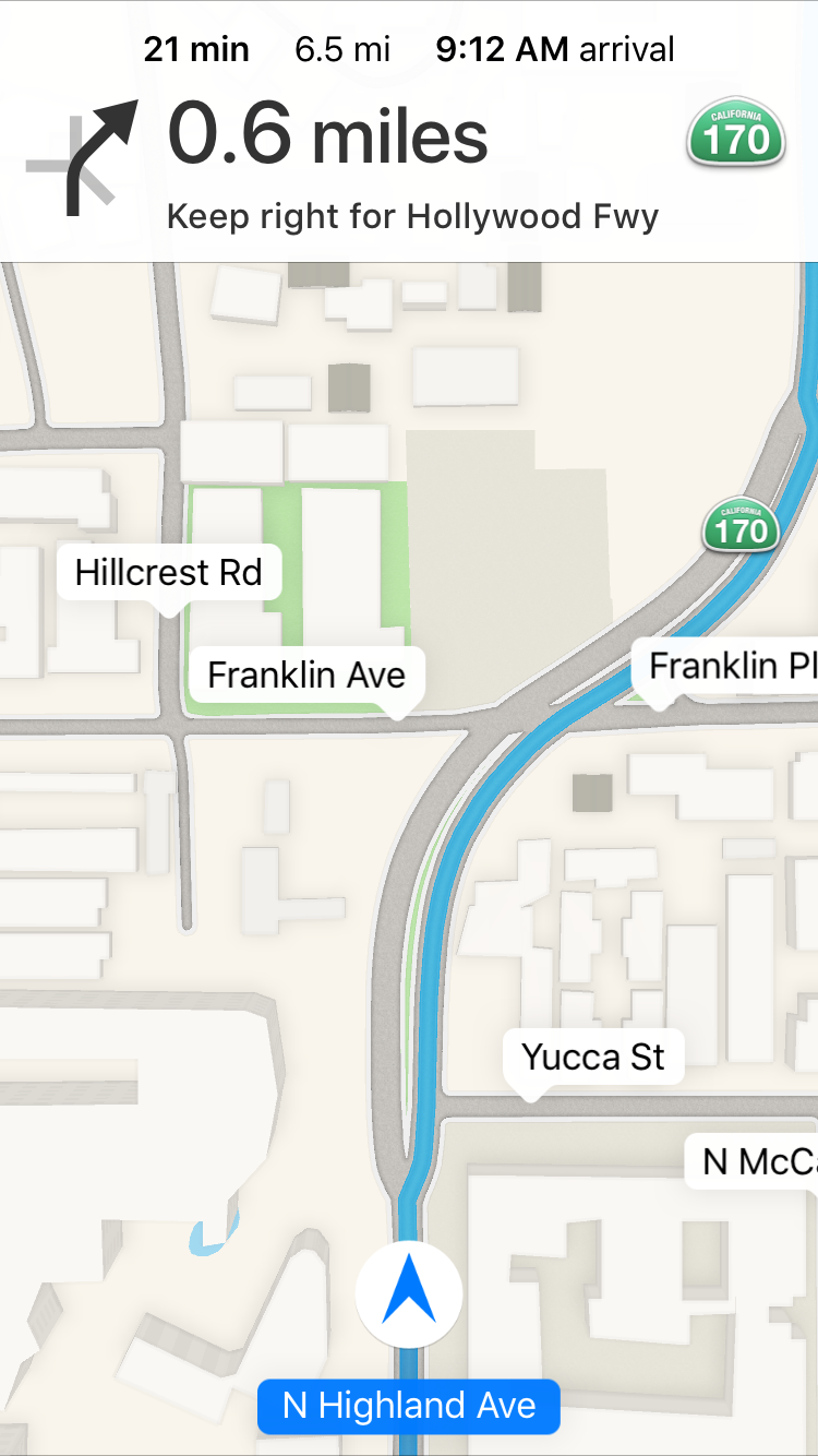
At heavy intersections, like Highland Ave. and Franklin Ave., you see no information about the flow of traffic in any direction. Instead of blue, you should see the streets run red with the blood of the Traffic God. Woe betide thee that commute on his most sacred of poorly designed intersections!
Tonight, Apple Maps routed me down Cahuenga to Highland. That sent me past the large, somewhat famous, amphitheater known as The Hollywood Bowl. Not a big deal, unless there’s an event at The Bowl. Guess what? There was an event! Van Halen! There were orange, safety cones and traffic cops directing at intersections. Apple Maps just herp-derped me through that. The only difference in the display was the estimated arrival time slowly ticking upward as I crawled.
On exactly one occasion I had Apple Maps present me with a yellow bar across the top, and Siri’s voice notified me that there was a delay due to an accident. (No alternate routing was provided on this occasion.) Waze has a leg up on Apple and Google when it comes to accident notifications. You even get notified about which lane the accident is in. Google sources some Waze data, but isn’t as specific. On the 101 N last night there was a very sudden slowdown, without warning, at a time of night when there shouldn’t be traffic at all. I waited patiently for Apple Maps to let me know what it was, and Apple Maps was oblivious to it. There was apparently a car accident that closed two lanes, and the car was being loaded on to a flatbed truck, so it wasn’t recent. Why Apple Maps kept silent about it, I don’t know.
Google Maps, in contrast, indicates traffic in several places. When cars are moving slowly, the road is red, as well as the estimated travel time. It serves as an appropriate cue that Google knows the street I’m on is slow, and thus I trust that Google is correctly monitoring the flow of cars. When Apple Maps has an unchanging interface, and an estimated arrival time that keeps ticking up, I have no sense that they understand the clusterfuck I’m stuck in. It’s not that Google Maps clears traffic, but it reassures you that it knows of it.
Google also provides alternate route suggestions as traffic conditions change. Sometimes there’s a prompt for a different route that will save X number of minutes. If I don’t accept the change, then I putter along on the current route. Far more often, I see the little gray paths with estimates of how many minutes faster, or slower, the route is.
I must ding Google for those little gray routes though. Often times the minute-by-minute fluctuations of traffic change on those paths so they are not always improvements. Also, Google’s app will occasionally lay several of the route suggestions on top of each other. For instance, you might be on Melrose, and the original path is to make a left at Highland, you see a suggestion to stay on Melrose and it will be 3 minutes faster. You tap it, and get a slower route. Zoom out and you’ll see that there were two routes it was suggesting that coincided at Melrose, so you got a route, but not the fast one you thought you were seeing. Why this behavior has persisted is beyond me, but it’s been there since they put these branching suggestions in.
Lanes
Lane guidance is a feature present in Google Maps, but not found in Apple Maps. I find it invaluable when I am traveling in a congested area and unfamiliar with where turn lanes, or exits, will split and join. Some exit lanes might quickly expand in to three lanes with turns in different directions, and Google Maps will tell you which ones you can be in, or even that you will be fine in the lane you’re already in. It’s a comfort, but not a requirement. If you miss a turn, or can’t get to an exit lane, then any map app will reroute you. It’s just nice to reduce the rerouting.
It’s not flawless though, and Apple could learn from Google’s mistakes if they ever implement this feature. Google notifies you of the lane arrangement as it will be when you need to change lanes, not in terms of the lane arrangement you’re currently in.
An irritating example of this is traveling through Downtown LA. The Google Maps issue is that the number of lanes on the 110, heading toward Santa Monica, changes rapidly. You’ll be notified to get in the exit lane to merge from the 110 to the 10 around the 7th avenue exit. If you immediately maneuver to the lane, in the freeway as you currently see it, then you’re in the wrong spot. Two more lanes will merge on to the right of you before you get off, and Google Maps was including those lanes in the guidance it gave when they weren’t there. Ugh.
It took me a bit to wrap my head around the way this guidance gets delivered, but I still prefer it to Apple Maps, which cheerfully asks you to exit right, sometimes with little warning.
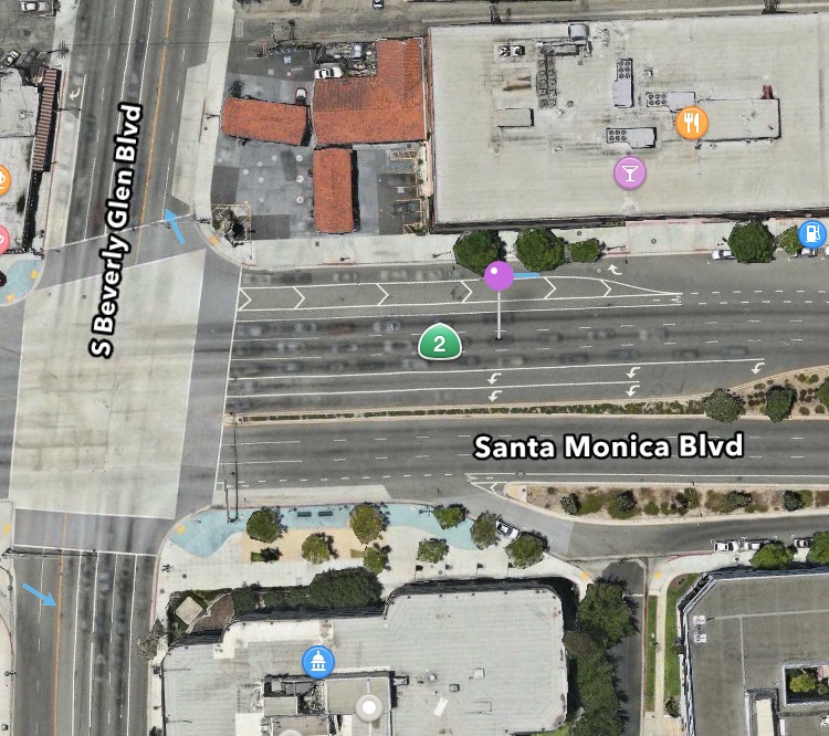
Apple Maps also seems blithely unaware of where special turn lanes start and stop, unlike Google. On a major roadway, it is not unusual to have a left turn lane start a significant distance from an intersection, and feature a solid, white line to deter people from making last minute lane changes. When making a turn from Santa Monica Blvd. to Beverly Glen Blvd., Apple Maps verbally alerted me to make a left after it was no longer legal to do so.
I have it on good authority that the vans Apple is driving around have lidar, and that lidar can be used for figuring out lanes. The more light will bounce off the reflective paint than off of anything else, even reflective cars. They might just be throwing away all that data and using the lidar to make really neat, really useless flyovers, but I hope they are using it to determine lanes.
Until We Cross Paths Again
I’m not even remotely on the fence about this decision. I am very disappointed because it would be the most convenient, OS-integrated, privacy-focused application for me to use. I simply value efficiency too much to rely on it in high-traffic LA. I hope it continues to improve, and that they continue to build in features that help it better estimate, and communicate, road conditions, and provide me with an interface that demonstrates that.
Category: text